Corentyne Block, Offshore Guyana
Utilizing seismic and well data to define the pressure regime and reservoir distribution in the Guyana Basin.
Challenge
To understand the complex relationship between the pressure regime and reservoir distribution in the Corentyne, Block, offshore Guyana.
Solution
Generate a synthetic well tie to accurately correlate the stratigraphic units from the well to the seismic to understand the pressure ramps encountered during the drilling operations.
Perform advanced seismic interpretation from the well data across the block area using various geophysical techniques to define the geomorphologies and reservoir architecture. Integrate the outputs to enhance the understanding of the subsurface.
Results
The prospective reservoir units and associated pressure regime has been accurately defined and integrated into the prospect portfolio.
The results assisted with the operational planning for the 2nd exploration well.

Introduction
The Kawa-1 well located in the Corentyne Block, Offshore Guyana was drilled in water depths of 1,174ft and to a Total Depth of 21,578ft. The well encountered 177ft of net hydrocarbon bearing sandstones across multiple intervals in the Cretaceous. No Rotary Side Wall Cores (RSWC), fluid samples or pressure tests were successfully performed during operations. This may have inferences regarding the rock quality at these depths, However, poor hole conditions can not be discounted for some of these operational issues.
Seismic Attribute Analysis
An advanced well and seismic analysis was undertaken and performed across the entire block area to enhance the understanding of the prospectivity as well as the PPFG.
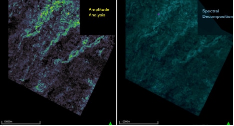
Various geophysical techniques were employed to unlock the complexities within the various stratigraphic units. These included amplitude analysis including AVO, spectral decomposition whereby various frequencies were blended to define the reservoir architecture and understand the homogeneous and heterogenous relationships that exist across the prospective reservoirs.
Geobodies, PPFG and Well Planning
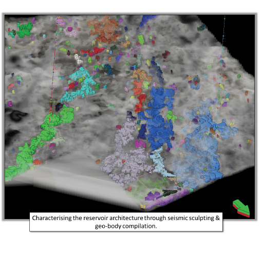
Geobodies were defined and generated within the prospective reservoir intervals from the available seismic datasets. This gave a 3D visualization of potential connected sand bodies that fed into the subsurface team’s volumetric assessments and exploration and appraisal well planning.
The PPFG model also incorporated the geobodies and allowed for a more refined understanding of the pressure regime in the offshore area, which resulted in a much safer and operationally efficient 2nd exploration well.


Client Feedback can go here
“We Strive to Excel”
Back to the Case Studies Page
